* Winner of the Medieval Academy of America’s 2019 Digital Humanities Prize *
Project Manager: Dr. John Wyatt Greenlee, PhD
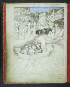
Mandeville Setting Out on His Journey (BL Additional 24189, f.3v)
Project Description:
The 14th century travel book and geography, The Travels of Sir John Mandeville provides readers with a fantastical tale of a man’s (supposed) journey from England to the farthest edges of the world. Sir John, the books’ narrator, tells stories of the sanctity of the Holy Land, of the wickedness of distant pagans peoples, and amazing and monstrous races that inhabit the corners of the globe. Taken as a whole, Mandeville’s book offers a remarkable insight into medieval ideas about geography, and about the way that the world was put together.
Students often attempt (and fail) to overlay the world that Mandeville presents to them onto a modern map — trying to visualize the geographies of The Travels through a modern lens. This failure comes not from lack of imagination, but rather because students are working with the wrong frames of reference. Mandeville’s text does not describe a global geography that accords with modern cartographic principals, but his book does mimic closely that most medieval form of map: the mappamundi.
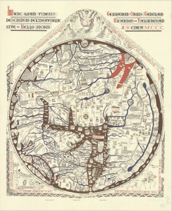
1989 Reproduction of the Hereford Map
Mappaemundi provide images of the world that relied on the wide range of sources available to their authors. Their authors were generally less concerned with capturing the geographic accuracy of the world as they were with using the terrestrial space of the globe as a stage on which to craft a pictorial universal history — a Christo-centric history to ran from the dawn of mankind in the Garden of Eden through to the Final Judgement.
Like Mandeville’s text, medieval mappaemundi are often difficult for students to approach. They are oriented differently than modern maps, and play by very different rules. Geographic accuracy and scale are less important on these medieval maps than are issues of history and symbolic scale — the Holy Land, for instance, is usually conspicuous both by its large size and its central location, which is a reflection of its spiritual importance to the world, rather than its geographical importance.
This project seeks to combine Mandeville’s text with one of the largest and most famous of the mappaemundi — the Hereford Map — in an attempt to use the two media together to make them more individually comprehensible. Using a legible copy of the Hereford map, I have annotated numerous locations on the map that also appear in Mandeville’s text. Clicking on these locations will bring up relevant selections from the text, and allow views to both understand Mandeville’s text within its proper framework, and to explore the foreign geographies of the map with a guide.
This project was initially made possible by a grant from Cornell University’s Olin and Uris Libraries Summer Digital Humanities Fellowship Program, and with the generous help of the library staff. The Mapping Mandeville Project is listed with the Medieval Academy of America’s Medieval Digital Resources Database.
![]()